
With Creaform’s new scanner, Torino Polytechnic’s DITAG department was able to capture details like never before. Its portability, accuracy, ease of use and very competitive pricing made this tool very well adapted to DITAG’s heritage preservation organizations’ needs.
Politecnico di Torino (Torino Polytechnic) (Torino, Italy) is a renowned engineering and architecture school and one of Northern Italy’s most prestigious technical and scientific institutes. It offers a wide range of academic programs, from aerospace engineering, telecommunications and biomedical and mechatronic studies to fields such as industrial design, motor vehicle engineering, cinema and media engineering.
One of the institute’s departments—the Land, Environment and Geo-Engineering Department (DITAG)—is involved in research and training in sectors connected to the environment, resources and land, and it continuously strives to research technologies with a potential to help protect and ensure the sustainable use of resources. With such a variety of subjects offered and a large number of specialized research groups working within the department, DITAG covers a wide range of activities. Although the many groups’ fields of interest are different, they all pursue the same goal, which is “to safeguard both natural and manmade environments and to ensure their proper use and development.”
The Challenge
 One important field of activity in the DITAG land and resource group is cultural heritage documentation, which commonly includes architectural surveys and land and environmental applications. DITAG focuses on the creation of accurate 3D models, which is very useful for reproducing, restoring and conserving monuments and other artifacts such as statues or furniture. The Fontana di Melograno is an example of the kind of monument surveyed by DITAG.
Instruments commonly used for land and monument surveying are mostly based on LIDAR (Light-Imaging Detection and Ranging) technology. These instruments allow long range scanning (up to 984 ft) of relatively large parts, but the resolution and accuracy that they provide are often too low to effectively capture details (repeatability of 0.078 in). It is almost impossible to perform accurate scans (less than 0.078 in) of detailed features on monuments using LIDAR technology. This limitation considerably reduces the effectiveness of applications, especially with regard to objects with small features that require high resolution.
Some newer technologies, like structured light scanners, provide accuracies and resolutions that meet DITAG’s needs (accuracies of 0.002 inches can be attained if used properly), and can be a good solution, especially in stable environments such as a laboratory. The problem that remains is that these technologies are very sensitive to ambient light and the surrounding environment, which makes them hard to use outside and in uncontrolled environments like the ones DITAG works with most often (most subjects are monuments that cannot be taken into a lab). Also, these scanners generate a huge amount of data that can take a long time to process, especially when the parts scanned are large.
Another problem with these two technologies has to do with scanning complex shapes and convex geometries. To perform a full scan of such a part (e.g., a statue), information must be taken from all around the object and from many points of view in order for the entire surface to be scanned. To capture data from many points of view, a new setup is needed each time, which is time consuming. Also, the various sections of the scan must be aligned in post-processing, which may result in a loss of accuracy.
DITAG’s challenge was to find a technology for cultural heritage surveying that would quickly produce high-accuracy scans in an uncontrolled environment. One appealing solution would be to find a tool that makes it possible to easily scan parts of varying sizes and shapes, especially objects that have both convex and concave surfaces. Such a tool would also need to be more affordable, easy to use and easier to carry around than existing tools available on the market.
The Solution
 Having heard from across the ocean that a major breakthrough in 3D scanning had been achieved, the people from DITAG decided to turn to Creaform to learn more about their flagship line-up of Handyscan 3D portable self-positioning laser scanners that deliver high resolution and an accuracy of up to 0.05 mm (0.002 in).
The Handyscan 3D scanner uses two cameras, four LEDs placed around each camera, a red laser cross and retro-reflective adhesive targets. Unlike conventional reference systems and because the positioning stickers are actually applied onto the part, the reference system of the scan is directly attached to the part itself, meaning that there is no need to immobilize the part and that ground vibrations or other disturbances around the scanner will not affect measurement, which greatly improves the accuracy of the scan. To set the reference system, targets must be affixed onto the object following an irregular mesh pattern, and then surveyed with the Handyscan 3D and gathered into a unique reference system located on the object. The device calculates its position in space in real time via triangulation.
The scanner first projects a red laser cross on the part; then, the part reflects an image of the cross that is captured by the scanner’s cameras and used to create a high-resolution mesh of the surface.
All of these steps are possible thanks to VXelements, the proprietary data acquisition software that powers Creaform’s portable 3D measurement technologies. It is also possible for the operator to control the completeness of the acquisition by looking at the real time image generated by VXelements directly on the computer screen. The software interface is easy to use and makes it possible to view the acquired surface as it is being scanned.
Another feature of the Handyscan 3D is its ability to generate a direct meshed model of the surface at the user’s choice of resolutions. The mesh model may combine multiple resolutions to ensure high accuracy and a manageable file size. Flatter surfaces require less resolution while more detailed or irregular surfaces require increased resolution.
Putting the Handyscan 3D to the test
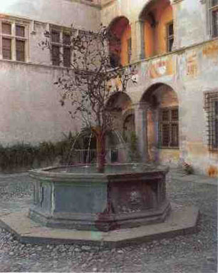
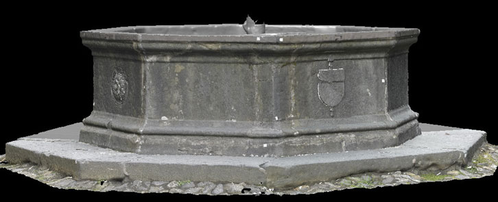
One monument that DITAG used the Handyscan 3D for was the Fontana di Melograno, located in the Aosta Valley region of Italy. Some of the fountain’s old stones had been damaged by water and needed to be restored. The restorers’ approach was to protect the stone with a special plastic that would be modeled to the exact shape of the interior of the fountain. The accuracy required was established at 0.02 mm (0.078 in.) or less. No data were needed to restore the outside walls, but it was compiled nonetheless for documentation purposes. Overall, the level of accuracy needed for the outside walls was not high, but some areas containing high levels of detail required a high resolution.
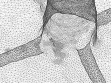
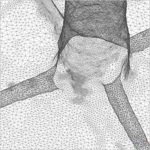
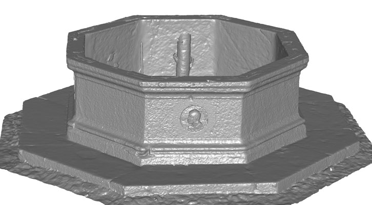
To complete the project, the Handyscan 3D was used in collaboration with a LIDAR system. The data from the interior and detailed areas of the exterior, which required a high level of accuracy, was acquired using the Handyscan 3D. Since the surface being surveyed was very large, numerous reflective targets had to be affixed to it and the scanning process had to be split into eight different scans. However, the overall time savings made possible by this handheld and self-positioning technology proved worthwhile. The remaining exterior areas were captured using LIDAR technology since the accuracy level required was not as high as the interior surfaces.
The resulting set of data was a multi-resolution representation of the fountain with all the information necessary for restoration and a much higher degree of accuracy. Figure 3 shows the result of the data combination from both technologies.
Conclusion
The Handyscan 3D helped DITAG widen its field of expertise by providing it with new data acquisition possibilities. With the same tool, DITAG is now capable of reverse engineering and restoring both small cultural heritage objects (statues and furniture) as well as large monuments. All these benefits are now obtained in less time and with a higher level of accuracy than before.
The Handyscan 3D delivers a level of accuracy and resolution that past technologies couldn’t achieve in uncontrolled environments, while adding considerable flexibility to cultural heritage surveying. Its portability, accuracy, ease of use and very competitive pricing make this tool very well adapted to DITAG’s and other heritage preservation organizations’ needs. The Handyscan 3D has also proved to be very useful and powerful in other specialized fields such as automotive, biomechanics and aerospace.